TAMBORA, INDONESIA

erupted for more than 50 cubic kilometers of magma. It caused a lot of destruction and killed more than 100,000 people, directly and indirectly. The massive Tambora is a stratovolcano that forms the entire 60-km-wide Sanggar Peninsula on northern Sumbawa Island. It grew to about 4000 m elevation before a major explosion destroyed its summit and left a pre-1815 caldera more than 43,000 years ago. It is also believed that the eruption produced tsunamis with waves possibly as high as 10 meters.
Location: Island of Sumbawa, Indonesia (found
in the Pacific Ring of Fire)\
MT.PELEE, WEST INDIES
MT.PELEE, WEST INDIES

The explosive eruption of Mt. Pelee happened last
May 10, 1902. With a population of upward of 25,000 persons, the city has been
totally destroyed, and the survivors are reported to number less than two
score, nearly all of them burned, wounded, and suffering awful torturesMount Pelee is a a great volcano that is believed to be extinct a
long time ago, suddenly awoke from the sleep of many years. Out of the mouth of
the treacherous crater, around which nestled the summer villas and the pretty
homes of the wealthier of the French West Indian residents. (from:http://www.publicbookshelf.com/public_html/The_Great_Republic_By_the_Master_Historians_Vol_IV/mountpele_ge.html)
Location: Martinique
MT. KRAKATOA, INDONESIA

he tsunamis that followed the collapse of the volcano into the caldera below sea level.
The island of Krakatau (Krakatoa) is in the Sunda Strait
between Java and Sumatra. It is part of the Indonesian Island Arc. Volcanic
activity is due to subduction of the Indo-Australian tectonic plate as it moves
northward towards mainland Asia. The island is about 3 miles wide and 5.5 miles
long (9 by 5 kilometers).
Location: Sunda strait between the islands of Java and Sumatra.
NEVADO DEL RUIZ, COLUMBIA
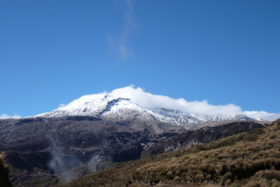 Nevado del Ruiz is an active volcano, located in a compact
cluster of volcanic mountains near the center of Colombia. The area is included
in Los Nevados National Park, and is easily accessible by road. It is probably
the most popular climbing area in Colombia, as well as a popular ski spot in
winter. Some snow remains on the mountain year-round. Nevado del Ruiz is not
only the highest mountain in the region, but is one of the easiest to ascend,
straight up the snowy west slope from a parking lot at the base of the
mountain. A traverse of all four peaks requires
about a week. More than 23,000 people were killed in Armero, Colombia when
Nevado del Ruiz erupted on November 13, 1985.
Nevado del Ruiz is an active volcano, located in a compact
cluster of volcanic mountains near the center of Colombia. The area is included
in Los Nevados National Park, and is easily accessible by road. It is probably
the most popular climbing area in Colombia, as well as a popular ski spot in
winter. Some snow remains on the mountain year-round. Nevado del Ruiz is not
only the highest mountain in the region, but is one of the easiest to ascend,
straight up the snowy west slope from a parking lot at the base of the
mountain. A traverse of all four peaks requires
about a week. More than 23,000 people were killed in Armero, Colombia when
Nevado del Ruiz erupted on November 13, 1985. Location: Colombia
MT.UNZEN, JAPAN

The eruption of Mt. Unzen in 1792 is the most
catastrophic and deadly in all of Japan’s history. The initial eruption
triggered a landslide and tsunami. Mt. Unzen consists of a group of composite
volcanoes and they are located east of Nagasaki. It is said that most of the
death toll was as a result of the landslide and tsunami; evidence of the
devastating landslide can still be seen today.
LOCATION: Shimabara Peninsula of Nagasaki Prefecture, Japan (found in the
Pacific Ring of Fire)
MT.VESUVIUS, ITALY

This
is possibly one of the most famous volcanic eruptions in history and it is
particularly infamous due to the burial of two Italian towns, Herculaneum and
Pompeii. This eruption is so well documented due to the eyewitness account of
Pliny the Younger. During this eruption Mt. Vesuvius expelled a deadly cloud of
volcanic gas, stones, ash and fumes that rose to a tremendous height of 33km.
The eruption lasted two days and the eruption was made even more tragic because
of the fact that the unsuspecting residents of the Bay of Naples were unaware
that they were living in the shadow of a deadly volcano.(From:http://www.heritagedaily.com/2014/08/top-10-deadliest-volcanic-eruptions/104313)LOCATION: Province of
Naples, Italy
THE LAKI VOLCANIC SYSTEM, ICELAND

LOCATION: South of
Iceland
MT. Papandayan, INDONESIA
 Situated on the Indonesian island of Java, Papandayan is a crater-filled
semi-active volcano. In 1772, one side of the volcano exploded and avalanched
into the surrounding 40 villages, destroying them completely. Over 3,000
villagers were killed. The volcano is still considered very dangerous and much of the surrounding area is restricted – especially considering
there have been smoke, tremors and minor eruptions in 1923, 1942, plus several,
all increasing in strength, in 2002. (from: http://www.toptenz.net/top-10-deadly-volcano-eruptions.php)
Situated on the Indonesian island of Java, Papandayan is a crater-filled
semi-active volcano. In 1772, one side of the volcano exploded and avalanched
into the surrounding 40 villages, destroying them completely. Over 3,000
villagers were killed. The volcano is still considered very dangerous and much of the surrounding area is restricted – especially considering
there have been smoke, tremors and minor eruptions in 1923, 1942, plus several,
all increasing in strength, in 2002. (from: http://www.toptenz.net/top-10-deadly-volcano-eruptions.php)
LOCATION: Indonesian island of Java
MT. KELUT, INDONESIA
 When Mt. Kelut erupted in 1919 over 100 villages were destroyed
due to lethal lahars that traveled a distance for 40 kilometers. During this
eruption 38 million cubic meters of water were ejected from the Crater Lake.
The volcano has erupted on a large scale several times since 1919, including
once in 1966 and again in 1990.
When Mt. Kelut erupted in 1919 over 100 villages were destroyed
due to lethal lahars that traveled a distance for 40 kilometers. During this
eruption 38 million cubic meters of water were ejected from the Crater Lake.
The volcano has erupted on a large scale several times since 1919, including
once in 1966 and again in 1990.
LOCATION: Kelud Karangrejo, Garum, Blitar 66182, Indonesia
MT. GALUNGGUNG, JAVA INDONESIA
 The Volcano erupted in October in 1882. As well as killing 4,011
people the eruption also destroyed 114 villages. Mt Galunggung is located on
the Pacific Ring of Fire, a well-known collection of volcanoes along a
horseshoe shape around the coasts of Asia and the west coasts of Central and
South America. This particular eruption was a VEI (Volcanic Explosive Index) 5
volcanic eruption.
The Volcano erupted in October in 1882. As well as killing 4,011
people the eruption also destroyed 114 villages. Mt Galunggung is located on
the Pacific Ring of Fire, a well-known collection of volcanoes along a
horseshoe shape around the coasts of Asia and the west coasts of Central and
South America. This particular eruption was a VEI (Volcanic Explosive Index) 5
volcanic eruption.
LOCATION: Java, Indonesia
Walang komento:
Mag-post ng isang Komento